GEM Crustal Framework and Tectonics Module
A new view of global geology, accurately reconstructed back in time.
The GEM Crustal Framework and Tectonics Module is a spatially consistent model of the Earth’s crust built using basement terranes and structures. It provides an accurate, 4D view of the Earth, with detailed, structurally constrained, global plate reconstructions back to the Triassic. It is an innovative, predictive base for understanding our planet and its resources.
By understanding basins from the ‘bottom-up’, basin resources can be understood, evaluated and explored for in a much more effective way.
Intriguing Implications
>40% of the World’s known hydrocarbons overlie one type of basement terrane
>80% of the World’s source rocks were deposited in the tropics
The World’s most productive source rocks are a predictable consequence of plate tectonic restriction and global anoxia
Most conjugate margin plays are neglected – GEM enables accurate extrapolation from one margin to the other
Basement type and thickness determine basin heatflow
~30% of margins are formed via reactivation of basement dykes - these basins are very different
Basement inheritance explains most basin structures and crustal thinning geometry
What’s Included?
GEM Crustal Framework and Tectonics module is a digital product delivered in ArcGIS format, with plate models in PaleoGIS and GPLATES formats.
Fully attributed, global interpretations of:
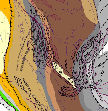
Basement terranes
Oceanic domains
Regional structures
Continent-ocean transitions
Tectonic events and basin phases
Basement + Paleozoic outcrop outlines
Detailed plate reconstructions of all layers back to the Triassic using Geognostics’ proprietary global plate model
8 focus areas showing structures and basins through time, plus high resolution plate tectonic animations
SE Asia
Gulf of Mexico – Caribbean
East Africa
Circum-Australia
Mediterranean – Black Sea – West Tethys
North Atlantic – Arctic – East Siberia
Central – Equatorial Atlantic
Equatorial – South Atlantic
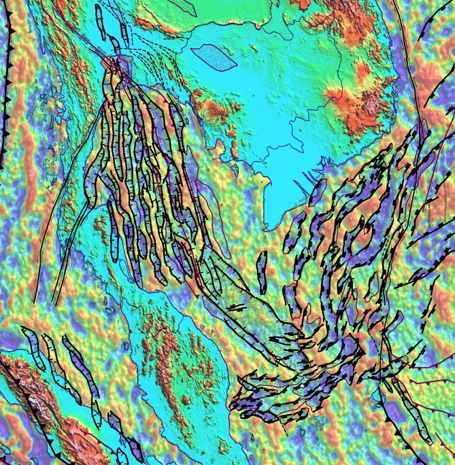
A suite of proprietary, high resolution Geognostics images of public domain global geophysical datasets filtered to enhance basin geology (gravity, magnetics, DEM
Tectonics
How can you quickly understand the tectonics and basin evolution of the most geologically complex regions on Earth?
What is the timing of extension and/or sea floor spreading? How does this relate to stratigraphy and petroleum systems?
Basement
What type of basement floors your basin?
How has it influenced basin evolution and heat flow?
Which basement terrane type underlies nearly half the World’s hydrocarbons?
Structures
What is the structural framework of your basin?
What is the deep architecture of the most prolific basins?
How have pre-existing basement structures influenced basins?
Where is the continent-ocean boundary in your basin?
Paleogeography
What was the paleo-latitude and paleo-longitude of your basin?
How do I accurately correlate successful play fairways from one conjugate margin to another?
Where and when were the best restricted marine source rocks deposited? [coming soon]

Predictive Paleogeographic Maps using GEM
The GEM Consortium
The GEM Crustal Framework and Tectonics Module is available via annual subscription, which includes consulting time, comprehensive support and regular updates.
The GEM Consortium currently comprises more than 15 members, including oil companies, minerals companies and universities. We hold regular GEM workshops with the consortium, and members are encouraged to steer and participate in its development.