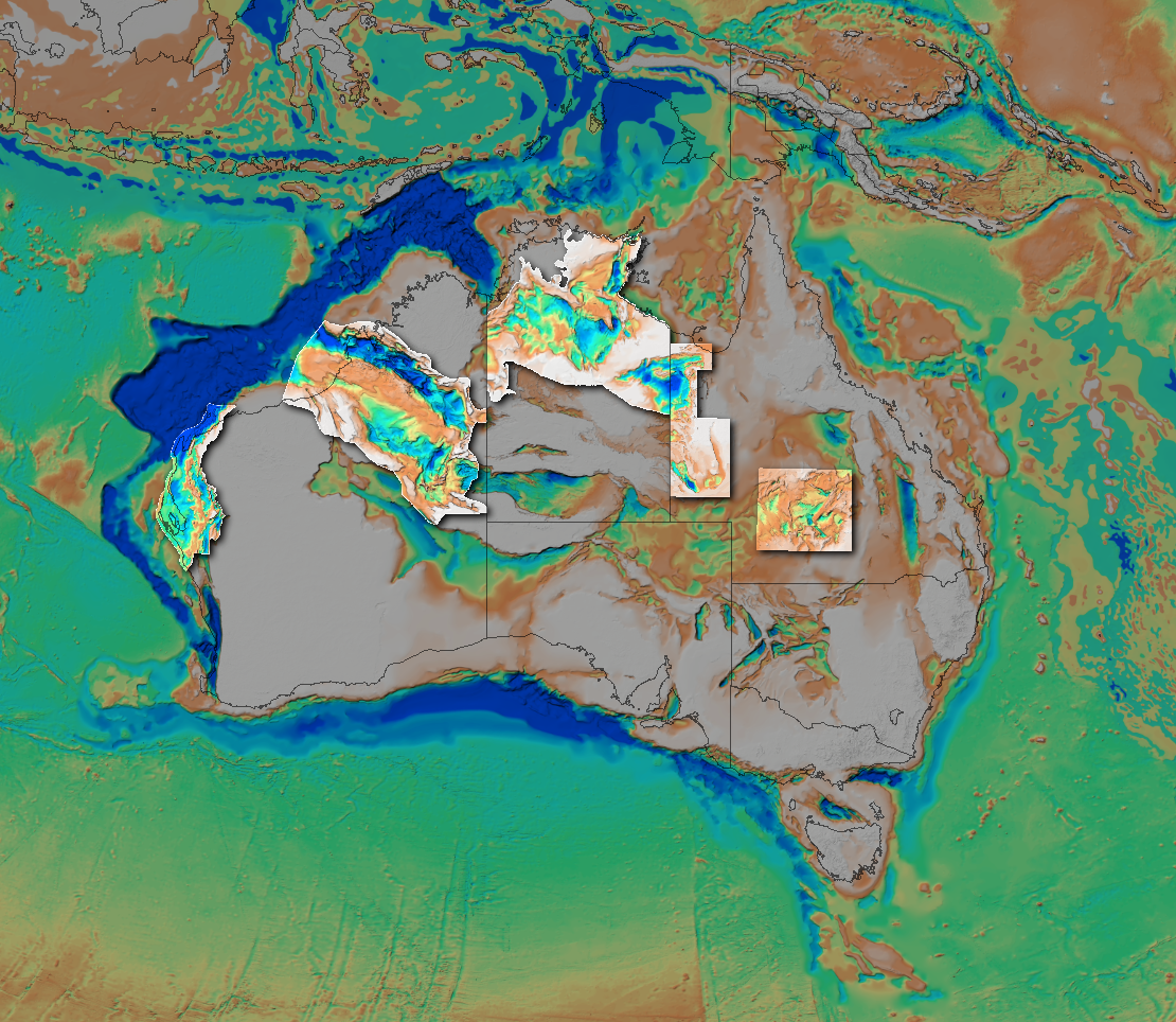
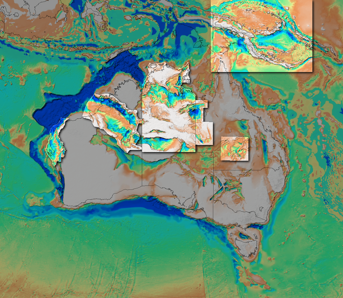
OZ SEEBASE 2021
OZ SEEBASE® 2021 is a regional, depth-to-basement model developed and licensed by Geognostics with the input and support of government and industry.
OZ SEEBASE® 2021 includes the Northern Territory SEEBASE® and GIS released by NTGS in January 2021. Papua New Guinea is also included, for the first time, based on Frogtech Geoscience’s 2018 Papua New Guinea SEEBASE Study.
Geognostics has also completed an integration of original interpretation datasets that, with improved gridding technology, now supports a higher grid resolution than previously available.
OZ SEEBASE 2021 is based originally on Frogtech Geoscience’s OZ SEEBASE® (2005) and OZ Proterozoic SEEBASE® (2006) Studies. In this update, basement is defined as the top of igneous or metamorphic crust at the base of undeformed sediments, regardless of age. Note that in deeper parts of some basins, such as the greater McArthur Basin, the deepest section may be metasedimentary.
Updates to OZ SEEBASE® 2021 include:
Addition of the Northern Territory SEEBASE® and GIS released by NTGS in January 2021
Addition of Papua New Guinea based on Frogtech’s 2018 PNG SEEBASE Study
Exclusion of the metamorphosed sediments of the Hamersley Basin and the Adelaide Fold Belt
Evaluation and integration of original interpretations spanning 15 years of SEEBASE construction across Australia
Improved gridding technology supporting higher grid resolution than previously available.
Geognostics welcomes the opportunity to upgrade areas for Clients and Government Agencies. Please contact us for further information to scope and plan an exclusive study.


Acknowledgements
Geognostics acknowledges the creation of the OZ SEEBASE (2005) and OZ Proterozoic SEEBASE (2006) technical studies and the subsequent upgrades undertaken by Frogtech Geoscience from 2006 to 2018, with authors/contributors of all reports and updates listed below.
Dr Tom Loutit, Dr Lynn Pryer, Dr Karen Connors, Dr Karen Romine, Dr Zhiqun Shi, Dr Sjoukje de Vries, Dr Cedric Jorand, Dr Donna Cathro, Dr Tim Debacker, Dr Jia-Urnn Lee, Dr Andrew Krassay, Dr Marie-Aude Bonnardot, Dr Yvette Poudjom Djomani, Mr Phil Henley, Dr Robert Holm, Mr Adam Kroll, Dr Jon Teasdale, Dr Guillaume Sanchez, Dr Peter Stuart-Smith, Dr Mike Ethridge (Tectonex), Dr Clive Foss (Encom), Ms Marina Den Hartog, Ms Nicola Fry, Ms Sophia Petrovich, Mr John Vizy, Mr Chris Pietrucha, Ms Grace Westerman, Ms Meredith Guy-Villon, Mr Allan Mills, Mr Paul Gardner, Mr Gabe Nelson, Mr Jen Deng Lee, Mr Callum Waugh, Ms Tehmina Mohsin, Dr Stuart Munroe (SRK), Dr Andrew Hamm (SRK)
Geognostics also acknowledges the sponsorship and contributions of government agencies and industry involved in the 2005 and 2006 SEEBASE studies and subsequent upgrades, including:
Contributing Companies:
Shell (Australia) Pty Ltd
SRK Consulting
Encom
Hess Exploration Australia Pty Limited
Santos Limited
Bengal Energy Limited
Central Petroleum Limited
ExxonMobil Exploration
Woodside Energy
Apache Energy
Anadarko Petroleum Corporation
Contributing Government Agencies:
Geoscience Australia
Northern Territory Geological Survey
Queensland Geological Survey
Geological Survey of Western Australia
Primary Industries and Resources, South Australia
New South Wales Department of Primary Industries
Geological Survey of Victoria
Department of Infrastructure, Energy and Resources, Tasmania

License Conditions, Disclaimer and Citation
OZ SEEBASE 2021 is released under a Creative Commons Attribution 4.0 International (CC BY 4.0) license that allows the sharing and re-use of materials: https://creativecommons.org/licenses/by/4.0/
Disclaimer: The conclusions and recommendations expressed in this Geognostics digital release represent the opinions of the authors based on the data available to them. No liability is accepted for the total accuracy of this report or related datasets, nor any commercial decisions or actions made resulting from this report.
Citation: Please cite this work as follows, if all or parts of the GIS are used or altered for use in other means: Geognostics, 2021. OZ SEEBASE® 2021 (March 2021). Geognostics Australia Pty Ltd, https://www.geognostics.com/oz-seebase-2021
The authors, government agencies and sponsor companies of the original 2005 and 2006 Frogtech Geoscience SEEBASE studies are acknowledged above.
NORTHERN TERRITORY
The Northern Territory SEEBASE and GIS project build on three previous studies that covered the region: OZ SEEBASE® (2005) and OZ Proterozoic SEEBASE® (2006), and the more recent greater McArthur SEEBASE® Structural Study and GIS (2018a) which were undertaken by Frogtech Geoscience for the NTGS.
The Northern Territory SEEBASE® and GIS was funded through the Northern Territory’s Resourcing the Territory initiative and is provided to explorers as a pre-competitive dataset. The NTGS is gratefully acknowledged for their technical contributions to the study and their review of this report. The NTGS and Geognostics also acknowledge the contributions from past work by Santos Limited (Amadeus Basin SEEBASE® Study) and Pangaea Resources Pty Ltd (McArthur Basin SEEBASE® Study). Proprietorial seismic data was also made available for the study by Empire Energy and Sweetpea Petroleum.
More information, and download links, are available here.


WESTERN AUSTRALIA
Canning Basin
The 2017 Canning Basin SEEBASE Study and GIS Data Package was funded by the Department of Mines, Industry, Regulation and Safety (DMIRS), Western Australia, as part of the Exploration Incentive Scheme (EIS). The study was undertaken by Frogtech Geoscience to improve the resolution of the 2005 OZ SEEBASE – including an improved identification and mapping of major structures, basement faults, structural architecture, basement composition and basement heat flow. The 2017 Canning Basin SEEBASE Study (GSWA Report 182) is available as a pre-competitive dataset for the petroleum and minerals industries through the DMIRS eBookshop.
Link to download the Canning Basin SEEBASE® Study: http://dmpbookshop.eruditetechnologies.com.au/product/2017-canning-basin-seebase-study-and-gis-data-package-geographical-product-n17by.do
Carnarvon Basin

The 2018 Carnarvon Basin SEEBASE Study and GIS Data Package was funded by the Department of Mines, Industry, Regulation and Safety (DMIRS), Western Australia, as part of the Exploration Incentive Scheme (EIS). The study was undertaken by Frogtech Geoscience to improve the resolution of the 2005 OZ SEEBASE – including an improved identification and mapping of major structures, basement faults, structural architecture, basement composition and basement heat flow. The 2017 Carnarvon Basin SEEBASE Study (GSWA Report 191) is available as a pre-competitive dataset for the petroleum and minerals industries through the DMIRS eBookshop.
Link to download the Carnarvon Basin SEEBASE® Study: http://dmpbookshop.eruditetechnologies.com.au/product/2018-carnarvon-basin-seebase-study-and-gis.do

QUEENSLAND
The North West Queensland SEEBASE Study and GIS (Queensland Geological Record 2018/03) was undertaken by Frogtech Geoscience for the Geological Survey of Queensland, Department of Natural Resources, Mines and Energy, in 2018.
Link to download the North West Queensland SEEBASE Study: https://qdexguest.dnrm.qld.gov.au/portal/site/qdex/search?REPORT_ID=106204&COLLECTION_ID=999

The Adavale Basin SEEBASE Study and GIS (Queensland Geological Record 2018/04) was undertaken by Frogtech Geoscience for the Geological Survey of Queensland, Department of Natural Resources, Mines and Energy, in 2018.
Link to download the Adavale Basin SEEBASE Study: https://qdexguest.dnrm.qld.gov.au/portal/site/qdex/search?REPORT_ID=109626&COLLECTION_ID=999
OZ SEEBASE 2005-2006
The original OZ SEEBASE Phanerozoic and OZ SEEBASE 2006 reports can be downloaded here https://geognostics.sharefile.com/i/iea5188169c0489fb

